Silk Road Project 絲路計畫
本計畫為一個三年期研究計畫,如獲補助,將針對西藏-喜馬拉雅和高加索-伊朗這兩個當今地球上最重要的亞洲造山帶進行對比研究,希望能更深入探索大陸碰撞造山演化。本計畫的研究構想奠基於申請人過去數年在西藏和周邊地區就岩漿活動與地體構造所從事的一系列工作,因此這個新計畫可視為CREATE整合型研究計畫的向西延伸。此外,本計畫將與中研院地科所發起的『高加索碰撞帶之綜合研究(NSC96-2119-M-001-001-)』和即將提出的相關主題研究計畫相互配合,分別利用地球化學和地球物理方法,推動整合研究。
基於申請人過去對青藏高原岩漿活動的研究心得,本計畫的研究重點為:
(1) 高加索-伊朗地區的第四紀乃至上新世的岩漿活動–即post-collisional岩漿活動,主要產地涵蓋喬治亞南部、阿美尼亞、伊朗西北部及伊朗東部等,並將與土耳其東部安納托力亞地區已有的大量資料對比。
(2) 高加索-伊朗地區廣泛的始新世(?)岩漿活動–即pre-collisional岩漿活動或傳統上認為的新特提斯洋板塊向北隱沒的產物。透過上述重點研究,預期本計畫應可對大陸碰撞前、後的岩漿成因、岩石圈結構、乃至地體構造環境演化等大陸動力學的基本議題提供新的制約,並進而探討安納托力亞-高加索-伊朗地區第四紀岩漿作用與新期活動構造的關係,促進台灣團隊在國際相關研究領域的地位。
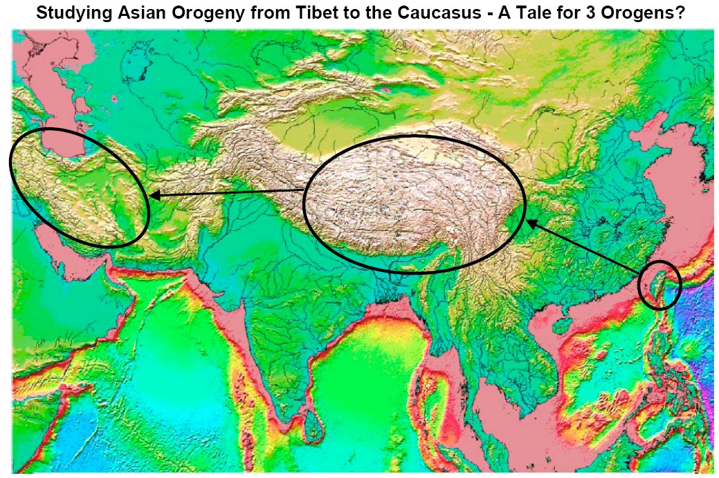
This project represents a main component of an integrated research project conducting for a comparative study of the Tibetan-Himalayan and Caucasus-Zagros orogens, two active and most important collision zones that occurred in East and West Asia, respectively, along the Tethyan orogenic belt. This integrated study aims at a comprehensive understanding of the evolution of continent collision, with the Tibet-Himalayas representing a well-developed or “mature” collision zone and the Caucasus-Zagros representing an intermediate-stage orogen. The results will be furthermore combined with constraints from nascent collision zones, such as Taiwan and New Guinea, to investigate the whole spectrum of geologic processes through which collisional orogeny evolves.
We have therefore assembled a capable team, with expertise in geochronology, petrology, geochemistry, seismology, geodesy, and tectonics, to work closely for an inter-disciplinary investigation of some fundamental problems in continental dynamics. While this project will focus on geochronological and petrochemical approaches, an ongoing, counterpart project led by colleagues at the IES, Academia Sinica deals essentially with geophysical investigations. We emphasize that one of our long-term goals is a holistic understanding of how and why pervasive volcanism has occurred for a long period during contractional mountain-building in the Caucasus-Zagros collision zone. Studying the record of igneous rocks is actually the very logical first step that would facilitate larger-scale, multi-disciplinary geophysical works. The Principal Investigator (PI) Sun-Lin Chung of this project has been a leading member of the CREATE (Comprehensive Research on East Asian Tectonic Evolution) project supported by the National Science Council, Taiwan that, in the past 10 years or so, allowed him to have successfully applied geochronological, petrochemical and isotopic techniques to study some important petrogenetic and tectonic problems in East Asia and elsewhere. For instance, following a pioneer study of the Tibetan tectonomagmatic evolution (Chung et al., 1998, Nature), he has reported numerous high-quality geochronological and petrochemical results for pre- to post-collisional magmatism within and surrounding the Tibetan plateau, through which the tectonic evolution of the plateau, or “the roof of the World”, has been better understood and its environmental impacts such as influences on development/reorganization of the SE Asian river system around the eastern Himalayan Syntaxis been explored.
This project, based on our successful experiences from studying the magmatic evolution in the Tibetan-Himalayan orogen, will particularly focus on: (1) the most unusual occurrence of widespread Quaternary igneous activities from the Turkish Anatolia to the Caucasus (southern Georgia and Armenia) and northwestern Iran, a zone of active contraction owing to the Arabia-Eurasia collision, to decipher the link between active tectonism and magmatism; and (2) the petrogenesis of Eocene(?) volcanism/plutonism over the Urumieh-Dokhtar belt related to the Neo-Tethyan subduction, to constrain the pre-collisional Eurasian lithospheric structure. Consequently, the pre- to post-collisional magmatic and tectonic evolution of the region may be better revealed. The overall results would be a fundamental contribution to the understanding of how continents assemble and evolve through collisional processes. It is also addressed that this key target in continental dynamics remains under-explored and that the proposed project presents a rare opportunity for the geosciences community in Taiwan to reach into an important natural laboratory where keen international competition is yet to fully develop.
I. Background and Introduction
1. The Tibetan-Himalayan Collision Zone
First of all, we briefly review our analogous work in the Tibetan plateau to illustrate the utility/ability of our approaches. Using a comprehensive collection of geochronological and chemical data, Chung et al. (2005) concluded four episodes of “post-collisional” magmatism in Tibet since the Late Cretaceous (Fig. 1). The spatio-temporal distributions of these igneous activities are interpreted as indicating four corresponding tectonic events.
The oldest event, at about 65 Ma ago, was linked to southward migration of volcanic arc along the active (Andean-type) continental margin of Eurasia prior to continental collision. The second event, near the end of Andean-type volcanism at about 45 Ma ago (including the cessation of voluminous Gangdese granites and Linzizong volcanics), may mark the breaking off of Neotethyan oceanic lithosphere that originally was attached to the northernmost edge of India.
Both the remaining two recent magmatic events in Tibet are interpreted as consequences of removal of thickened Eurasian lithospheric mantle. Temporally, the two events occurred in tandem, with a corresponding progression in space. At around 30 Ma, convective removal of thickened mantle lithosphere of the Lhasa terrane in southern Tibet is invoked as the thermal event that caused partial melting of thickened, lower continental curst of mafic composition, resulting in widespread adakite and ultra-potassic volcanism throughout the Lhasa terrane (Chung et al., 2003; Hou et al., 2004; Guo et al., 2007). Afterward, Indian mantle lithosphere advanced sub-horizontally farther northward and thickened the mantle lithosphere beneath the Qiangtang terrane in central Tibet, causing another event of convective removal around 15 Ma ago, providing the heat source responsible for recent potassic volcanism in northern Tibet (e.g., Chung et al., 1998 & 2005; Ding et al., 2003; Wang et al., 2005).
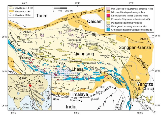
Fig. 1. Simplified geologic map of the Tibetan plateau, Himalayas and surrounding areas, with emphasis on the distribution of magmatic rocks (from Chung et al., 2005).
In the Tibetan-Himalayan orogen, knowledge about pre-collisional history, however, was limited because most of previous studies concentrated in post-collisional geology regardless of the consequence that any models proposed for Tibetan-Himalayan tectonic evolution thus situated actually on general assumptions of initial conditions with scarce data. Therefore, we carried out a systematic study of the Cretaceous-Eocene Gangdese Batholith and associated Linzizong volcanic succession from the southern Lhasa terrane for better understanding the magmatic/geodynamic processes that had been operating in the region before the India-Asia collision. This has so far resulted in three PhD theses (Chu, 2006; Lee, 2007; Wen, 2007) and several journal articles including in press or in review papers (e.g., Chu et al., 2006; 2007a & b; Lee et al., 2007a & b; Wen et al., 2007a & b).
2. The Caucasus-Zagros Collision Zone
In the aftermath of plate tectonics, evolution of the continental lithosphere is once again a focus of fundamental research in geosciences – but now with an important new perspective: Closing of ocean basins is the key process leading to continent collision. Continent-continent and arc-continent collisions, in turn, are the main processes responsible for the growth of individual continents and re-assembling of super continents (e.g., Dewey and Burke, 1973; Sengor et al., 1993; Windley, 1995). Specifically, an intervening ocean with a passive margin on one side and an Andean-type subduction zone (continent-ocean convergence) on the other side precedes continent-continent collision. Similarly, arc-continent collision results when a passive margin is juxtaposed onto a Mariana-type subduction (ocean-ocean convergence). To this end, the Arabia-Eurasia collision zone (AECZ) is unique as that even though the true continent-continent contact between Arabia and Eurasia seems to have initiated no later than 23-16 Ma in the early Miocene (Robertson, 2000; Golonka, 2004), a number of large-scale ocean basins are yet to close, including the Black and the Caspian Seas (Fig. 2). As such, this collision zone is uniquely important in understanding the intermediate stage of continent collision – the critical link in evolution between nascent collision zones, such as Taiwan and New Guinea, and mature zones, such as the Himalayan-Tibetan orogen and the Alps.
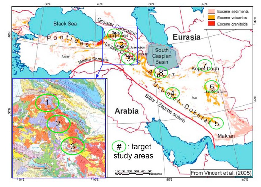
Fig. 2. Overview of tectonic setting of the Arabia-Eurasia collision zone (from Vincent et al., 2005). Whereas the Bitlis-Zagros suture denotes the plate boundary between Arabia and Eurasia, the Urumieh-Dokhtar belt that consists of Eocene volcanics and granitoids represents an Andean-type magmatic arc complex resulting from northward subduction of the Neo-Tethyan oceanic lithosphere before the continent collision. Note that in many localities cropping out the Eocene magmatic rocks, post-collisional volcanism occurred during the Pliocene-Quaternary. For example, the Trans-Caucasus volcanic field (inset), which covers an area of ~400 km by 400 km laterally, comprises abundant Quaternary volcanic rocks (in orange) and Eocene volcanics (in blue). The green circles (labeled 1-8) indicate the target study areas of this proposed project.
Not surprisingly, the importance of the AECZ has long been recognized in the literature (e.g., McKenzie, 1972). Whereas all active collision zones involves broad, diffuse regions of deformation, the AECZ has an intriguingly sharp northern boundary – defined by the co-linear trend from the Caucasus to Kopet Dagh (Fig. 2) – a feature clearly lacking in the mature India-Eurasia collision zone. Perhaps due to its past geopolitical situations that prohibit field investigations by most western researchers, this unique northern boundary of the AECZ remains under-explored. In contrast to intense international efforts in Taiwan and Himalaya-Tibet, large-scale, comprehensive projects in the field laboratory of Caucasus are conspicuously lacking.
II. Proposed Target Areas in the Caucasus-Zagros Collision ZoneThere are three main components of active tectonics in the Caucasus region (cf. Rebai et al., 1993). First are the WNW-ESE trending fold-and-thrust belts, examplied prominently by the Greater Caucasus ranges, consistent with the current N-S contraction between Arabia and Eurasi. Second, there are two major sets of strike-slip fault systems, trending NE-SW and NW-SE, in the southwestern and southeastern portions of the Lesser Caucasus, respectively. Third and perhaps the most intriguing tectonic feature of the Caucasus is a N-S trending zone of extension, accompanied by extensive, Quaternary or even Recent volcanic activities. For instance, the Trans-Caucasus volcanic field covers an area of over 400 km by 400 km laterally (Fig. 2). Despite lithospheric thickening that must accompany continental collision, the AECZ has had continual igneous activity of significant volume from Jurassic to present time (e.g., Adamia et al., 1981; Philip et al., 1989; Rebai et al., 1993). We propose to conduct detailed studies in three target areas in the Trans-Caucasus volcanic field, located in southern Georgia, Armenia and northwestern Iran, respectively (Fig. 2; labeled #1-3).
More significantly, the Trans-Caucasus volcanic field is actually the eastward extension of the voluminous volcanic field in Eastern Anatolia (cf. Keskin, 2003) where over half of the surface area is covered with young volcanic units that exceed 1 km in thickness in places and ranging from ~10 Ma to present in ages. We note that Eastern Anatolia, i.e., a 2-km high plateau and one of the best examples of continental collision, has been widely regarded as a younger version of the Tibetan plateau (e.g., Sëngor and Kidd, 1979; Dewey et al., 1986). Till now, there exist at least seven models invoking different driving forces that asserted controls on the Eastern Anatolian magmatic/geodynamic evolution: (1) tectonic escape of micro-plate (McKenzie, 1972); (2) subduction of the Arabian continent (Rotstein and Kafka, 1982); (3) upwelling and decompression melting of asthenosphere by extension (McKenzie and Bickle, 1988); (4) continental collision and resultant thickening of the Anatolian lithosphere (Dewey et al., 1986); (5) delamination of overthickened mantle lithosphere beneath Eastern Anatolia (Pearce et al., 1990; Keskin et al., 1998); and (7) slab steepening and then breakoff beneath a subduction-accretion complex in the region (Keskin, 2003; Sëngor et al., 2003).
In contrast to the Turkish Eastern Anatolia where a detailed seismic experiment project has been recently performed that, combined with the long-term studies on regional geology and magmatism, substantiate our understanding of not only the crustal/lithospheric structure but also geodynamic evolution of the region (cf. Keskin, 2003; for review), large-scale or systematic international investigations have been particularly lacking in the Iranian section of the AECZ. Nevertheless, judging from the geologic maps and scarce publications in English (e.g., Jung et al., 1983; Tirrul et al., 1983; Vincent et al, 2005), together with communications with our Iranian collaborators, we propose five specific target areas in the Iranian territory in this project. These include (1) Areas #4 and 5 for studying the subduction-related magmatism along the Urumieh-Dokhtar belt, (2) Areas #6 and 7 for studying the Eocene and Quaternary magmatism along the Sistan suture zone, a northern branch of the Neo-Tethyan suture zone and the boundary between the Lut/Arabia and Afghan blocks (Tirrul et al., 1983), and (3) Area #8 for studying Eocene magmatism in the Alborz tectonic belt (Vincent et al., 2005) and Mt. Damavand, the highest peak (>5200 m) in Iran and a Quaternary stratovolcano formed with the Alborz or ~20 km north of the Tehran City (Fig. 2).